
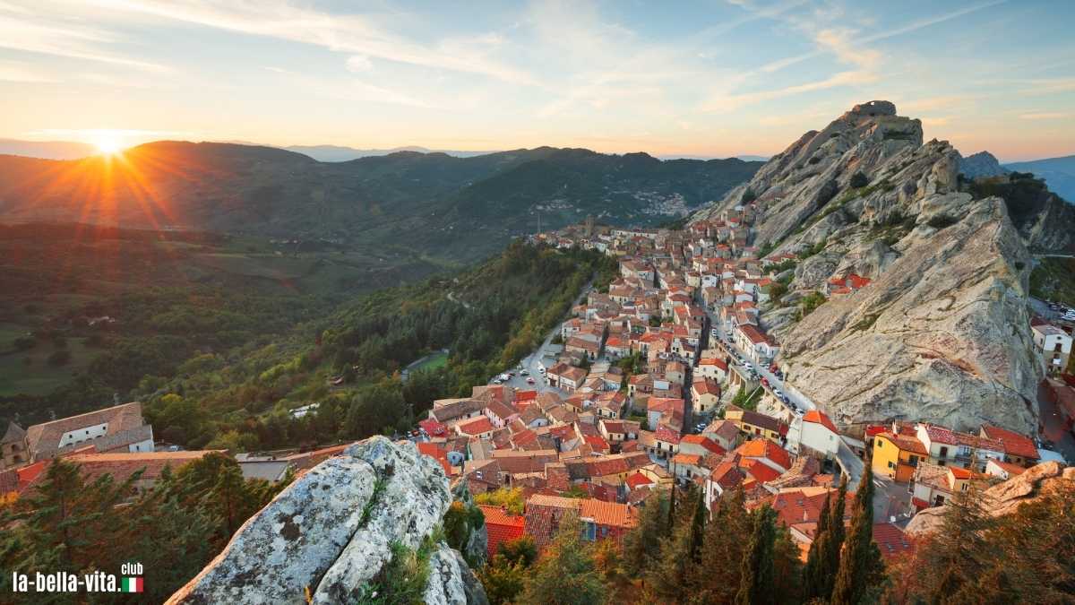
What a wow sight: Pietrapertosa in Basilicata Photo: stock.adobe.com/SeanPavonePhotoi
From our editorial team
If you want to experience the country away from beach loungers, selfie sticks and city tours, the best way is to set off. On foot. Because between Alpine ridges, high plateaus and olive groves lie small towns that don't live from sightseeing, but from atmosphere.
The real Italy doesn't have a sign at the entrance - but sometimes a beaten track. If you hike through these places, you will experience an Italy that has grown: narrow paths, old walls, natural viewpoints without railings - and meals that are often simple but could not be more honest. These villages can be hiked in day or multi-day tours and offer connections to regional hiking trails.
The feeling the world is envious of
1st Castelmezzano & Pietrapertosa in Basilicata

Photo: stock.adobe.com/stevanzz
The two villages of Castelmezzano and Pietrapertosa are among the most spectacular places in southern Italy - less because of their size and more because of their location. They nestle against the jagged rocks of the "Lucanian Dolomites", a mountain range that is visually reminiscent of the Alps, but has a typically southern climate: dry, windy and aromatic.
The path of the seven stones
The connecting element is the "Sentiero delle Sette Pietre", a hiking trail called the seven steps, which leads through a spectacular rocky landscape over a length of two kilometres: From Castelmezzano, it descends from an altitude of 925 metres down into the valley of the Torrente Caperrino at 660 metres and then climbs back up to Castelmezzano at 770 metres. The trail can be hiked in both directions.
*Ad Aluminium walking poles from € 27 / Amazon
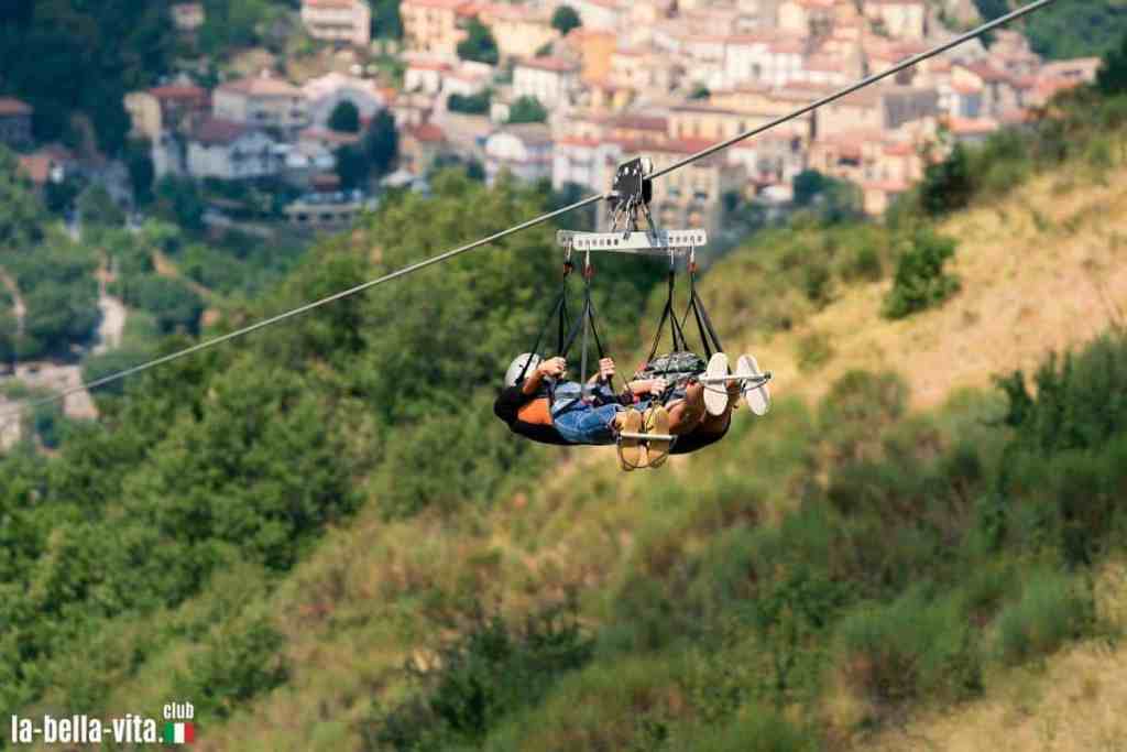
Photo: stock.adobe.com/BrunoBarillari
The cable car for the very daring
Those who dare can take the Volo dell'Angelo, a zip wire between the two villages, and fly through the gorge at a height of 400 metres. Those who prefer a quieter experience can climb the ruins of the Norman castle in Castelmezzano or follow old shepherd's paths up to Monte Caperrino.

Mystical hiking trail
The hiking trail is also an encounter with regional legends and tales. The basis for the themed trail is the book "Vito danced with the witches" by Mimmo Sammartino. There are seven stations, each with a stone sculpture - each representing a central word from the story: fate, magic, curse, witches, flight, dance, intoxication. This is where the name "Path of the Seven Stones" comes from.
Why people in Italy call their mum for the rest of their lives
Culinary delights
The region is also a culinary insider tip: homemade pasta such as strascinati (larger ear-shaped pasta), lamb dishes and the local red wine Aglianico del Vulture characterise the cuisine. Ideal for hikers looking for solitude and authenticity - and who want to experience real life in a mountain village.
- Location: Gallipoli Cognato National Park - Dolomiti Lucane
- Height difference: 229 m
- Hiking tip: Sentiero delle Sette Pietre (2 km - one route)
- Duration: a good 1.5 hours
- Level of difficulty: simple
- NotesThere is no public transport for the way back and little shade on the route (take enough to drink).
*Advertisement 1.5 litre water bottle for hiking / Amazon
More information (external links)
- Comune di Castelmezzano
- Comune di Pietrapertosa
- Tourism page Basilicata
- The cable car between the villages
- The Gallipoli Cognato National Park
- Here is the hiking trail on Komoot
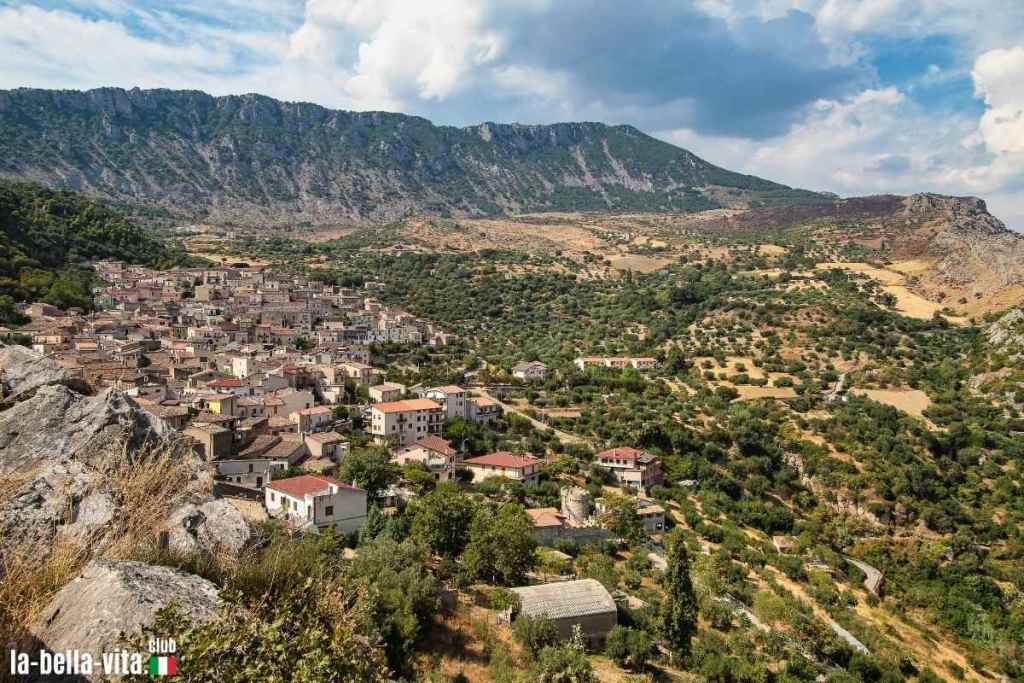
2 Civita in Calabria
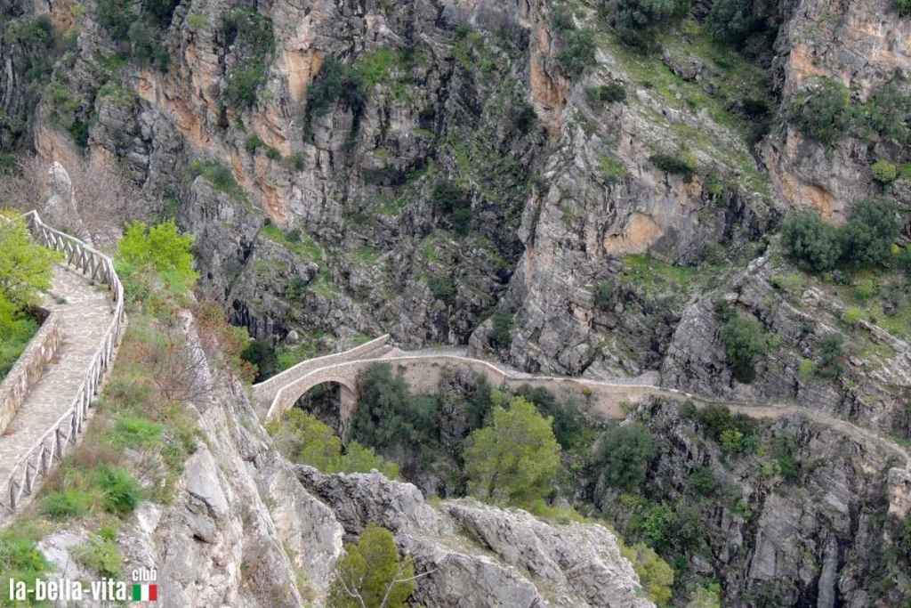
Civita is one of the oldest Arbëresh villages in Italy - founded in the 15th century by Albanian refugees who still maintain their culture today. The small village with only around 1,000 inhabitants is spectacularly situated above the Raganello Gorge, one of the most impressive canyons in southern Italy. From the famous Ponte del Diavolo, you can look down 30 metres into the wild riverbed.
*Ad XXL picnic blanket 22 € / Amazon

Only with a guide in the gorges
The Parco Nazionale Pollino is the largest nature park in Italy. The circular hiking trail begins at the Belvedere viewpoint in Civita, where you can admire a unique panorama of the valley. The route heads towards Ponte del Diavolo before reaching the gorges of the Raganello river. Access to the gorges is only permitted with a guide and from June to September inclusive.
A village like a museum
The village itself has been preserved almost like a museum: narrow alleyways, stone houses with oriental-style fireplaces and a Byzantine church with an iconostasis. Civita is a culinary delight: Lagane e ceci (homemade pasta with chickpeas), spicy ricotta and peperoncino are classics, as is the intense red wine from the area.
- Location: Pollino National Park
- Altitude: 450 m
- Hiking tip: Civita - Raganello Gorge circular route (3.9 km)
- Duration: just under 2 hours
- Level of difficulty: simple
- NoteAccess to the gorges is only permitted with a guide from June to September inclusive, and is forbidden for children under the age of 10 and only for groups of a maximum of 20 people.
More information (external links)
3rd Vogogna in Piedmont

Photo: stock.adobe.com/stefanopez
Vogogna is a medieval insider tip at the entrance to the Val Grande, the largest wilderness area in Italy. The Castello Visconteo catches the eye as soon as you arrive - a massive 14th century fortress that now serves as an exhibition centre. The village itself has retained its character: cobbled streets, weathered portals, flower boxes on every corner.
*Advertisement Sand-free XL beach blanket € 15.99 / Amazon
Various hikes lasting several days can be undertaken from here. The Great Walser Trail, the Traccia dei Walser, is a historic route that follows the old settlement routes of the Walser, a German-speaking ethnic group that lived here in the Middle Ages. The trail leads through Piedmont, Valle d'Aosta and the Swiss Ticino. The total length of 153 kilometres can be covered in 11 stages. Particularly impressive in autumn, when the chestnut forests turn golden.

Photo: stock.adobe.com/AleMasche72
Those returning from the hike in the evening can enjoy polenta with wild boar or gnocchi al Bettelmatt (with local mountain cheese) in one of the osterie. And if you stay longer, you can also visit Domodossola next door - another charming place for hiking enthusiasts.

- Location: Val d'Ossola, Province of Verbano-Cusio-Ossola
- Altitude: approx. 250 m
- Hiking tip: Circular hiking trail to Colloro (9.8 km)
- Duration: 3,3 hours
- Altitude metres: 350 metres
- Level of difficultymedium (good basic fitness required, paths are mostly secured)
More information (external links)
Ad Lightweight trekking rucksack € 35.99 / Amazon


*Advertisement Beach umbrella with UV protection € 19.99 / Advertisement